
Make a donation
Gear up for your next adventure:
As an Amazon Associate, this site earns from qualifying purchases at no extra cost to you.
Gangkofen topographic map
Click on the map to display elevation.
Make a donation
Gear up for your next adventure:
As an Amazon Associate, this site earns from qualifying purchases at no extra cost to you.
About this map
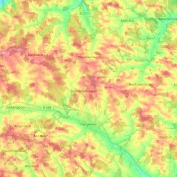
Name: Gangkofen topographic map, elevation, terrain.
Location: Gangkofen, Landkreis Rottal-Inn, Bavaria, 84140, Germany (48.39961 12.47006 48.52481 12.65428)
Average elevation: 1,545 ft
Minimum elevation: 1,345 ft
Maximum elevation: 1,716 ft
Make a donation
Gear up for your next adventure:
As an Amazon Associate, this site earns from qualifying purchases at no extra cost to you.
Other topographic maps
Click on a map to view its topography, its elevation and its terrain.
Make a donation
Gear up for your next adventure:
As an Amazon Associate, this site earns from qualifying purchases at no extra cost to you.
Hintergrindering
Germany > Bavaria > Landkreis Rottal-Inn > Seemannshausen
Average elevation: 1,535 ft