
Burwash topographic map
Interactive map
Click on the map to display elevation.
About this map
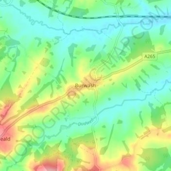
Name: Burwash topographic map, elevation, terrain.
Location: Burwash, Rother, East Sussex, England, TN19 7EP, United Kingdom (50.97761 0.36545 51.01761 0.40545)
Average elevation: 184 ft
Minimum elevation: 62 ft
Maximum elevation: 427 ft
Other topographic maps
Click on a map to view its topography, its elevation and its terrain.
Ticehurst
United Kingdom > England > East Sussex > Rother
Ticehurst, Rother, East Sussex, England, United Kingdom
Average elevation: 266 ft
Bexhill-on-Sea
United Kingdom > England > East Sussex > Rother
Bexhill-on-Sea, Rother, East Sussex, England, TN39 3PE, United Kingdom
Average elevation: 43 ft
Battle
United Kingdom > England > East Sussex > Rother > Battle
Battle, Rother, East Sussex, South East England, England, United Kingdom
Average elevation: 217 ft