Geolocate

FishHawk topographic map

Click on the map to display elevation.

About this map

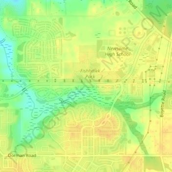
Name: FishHawk topographic map, elevation, terrain.

Location: FishHawk, Brandon, Hillsborough County, Florida, 33547, United States (27.84373 -82.22329 27.86373 -82.20329)

Average elevation: 79 ft

Minimum elevation: 20 ft

Maximum elevation: 105 ft

Hillsborough County trails, hiking, mountain biking, running and outdoor activities

Other topographic maps

Click on a map to view its topography, its elevation and its terrain.

Brandon

United States > Florida > Hillsborough County > Brandon

Average elevation: 62 ft

Dover

United States > Florida > Hillsborough County > Brandon > Aarons Place

Average elevation: 108 ft

Gear up for your next adventure:

🎒Trail Energy Bars - High‑calorie bars for hiking energy
🔪Outdoor Multitools - Essential survival tools for gear repair and field use
🏕️Family Camping Gear - Essentials for group camping trips
🔦Powerful Headlamps - Ultra-bright hands-free lighting for night navigation
🧣Merino Neck Gaiters - Multi-functional headwear for wind and sun protection

As an Amazon Associate, this site earns from qualifying purchases at no extra cost to you.