Geolocate

O Cebreiro topographic map

Click on the map to display elevation.

About this map
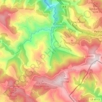
Name: O Cebreiro topographic map, elevation, terrain.

Location: O Cebreiro, Pedrafita do Cebreiro, Os Ancares, Lugo, Galicia, Spain (42.69477 -7.09795 42.74061 -7.01994)

Average elevation: 3,619 ft

Minimum elevation: 2,329 ft

Maximum elevation: 4,626 ft

Other topographic maps

Click on a map to view its topography, its elevation and its terrain.
Ferreiras

Spain > Galicia > Os Ancares > As Nogais

Average elevation: 3,363 ft

Gear up for your next adventure:

🌄Hiking Binoculars - Compact binoculars for scenic views and trail spotting
🏥Hiking First Aid Kits - Comprehensive medical kits for remote trail injuries
🚪Portable Camp Chair - Foldable chair for comfort at camp
🪶Survival Guide Book - Expert advice for emergency preparedness
🧯Emergency Survival Kit - All‑in‑one survival essentials for the backcountry

As an Amazon Associate, this site earns from qualifying purchases at no extra cost to you.