
Thank you for supporting this site ❤️
Make a donation
Make a donation
Gear up for your next adventure:
As an Amazon Associate, this site earns from qualifying purchases at no extra cost to you.
Hrafntinnusker topographic map
Click on the map to display elevation.
Thank you for supporting this site ❤️
Make a donation
Make a donation
Gear up for your next adventure:
As an Amazon Associate, this site earns from qualifying purchases at no extra cost to you.
About this map
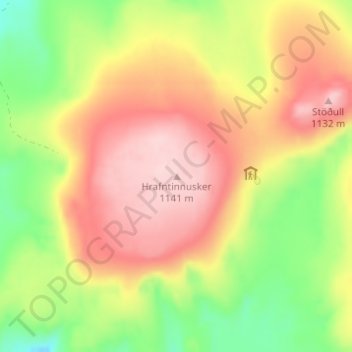
Name: Hrafntinnusker topographic map, elevation, terrain.
Location: Hrafntinnusker, Rangárþing ytra, Southern Region, Iceland (63.93293 -19.18089 63.93303 -19.18079)
Average elevation: 3,350 ft
Minimum elevation: 2,976 ft
Maximum elevation: 3,691 ft
Thank you for supporting this site ❤️
Make a donation
Make a donation
Gear up for your next adventure:
As an Amazon Associate, this site earns from qualifying purchases at no extra cost to you.
Other topographic maps
Click on a map to view its topography, its elevation and its terrain.