
Potrerito topographic map
Interactive map
Click on the map to display elevation.
About this map
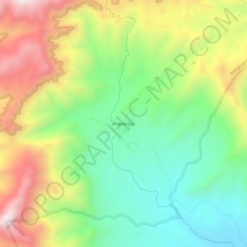
Name: Potrerito topographic map, elevation, terrain.
Location: Potrerito, San Juan del Cesar, La Guajira, Colombia (10.78699 -73.24729 10.82699 -73.20729)
Average elevation: 2,743 ft
Minimum elevation: 1,696 ft
Maximum elevation: 4,232 ft
Other topographic maps
Click on a map to view its topography, its elevation and its terrain.
San Juan del Cesar
Colombia > La Guajira > San Juan del Cesar
San Juan del Cesar, La Guajira, RAP Caribe, 444030, Colombia
Average elevation: 709 ft
El Barcino
Colombia > La Guajira > San Juan del Cesar
El Barcino, San Juan del Cesar, La Guajira, Colombia
Average elevation: 5,056 ft
Los Pondores
Colombia > La Guajira > San Juan del Cesar
Los Pondores, San Juan del Cesar, La Guajira, 444030, Colombia
Average elevation: 653 ft