Geolocate

Pencader topographic map

Click on the map to display elevation.

About this map

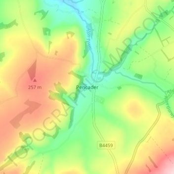
Name: Pencader topographic map, elevation, terrain.

Location: Pencader, Carmarthenshire, Wales, SA39 9HF, United Kingdom (51.98013 -4.28851 52.02013 -4.24851)

Average elevation: 597 ft

Minimum elevation: 289 ft

Maximum elevation: 984 ft

Other topographic maps

Click on a map to view its topography, its elevation and its terrain.

River Towy

United Kingdom > Wales > Carmarthenshire

Average elevation: 705 ft

Gear up for your next adventure:

Camping Coffee Makers - Enjoy premium coffee at the summit or campsite
🧥Waterproof Jacket for Hiking - Breathable and rugged rain jacket for outdoor excursions
🛠️Backpacking Tool Kit - Essential toolkit for outdoor repairs
🧭Outdoor Navigation Book - Learn advanced navigation skills
❄️Traction Cleats - Prevent slips on icy trails during winter hikes

As an Amazon Associate, this site earns from qualifying purchases at no extra cost to you.