
Biltmore topographic map
Interactive map
Click on the map to display elevation.
About this map
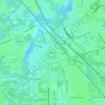
Name: Biltmore topographic map, elevation, terrain.
Average elevation: 26 ft
Minimum elevation: 10 ft
Maximum elevation: 52 ft
Other topographic maps
Click on a map to view its topography, its elevation and its terrain.
Oak Hill Park
United States > Florida > Duval County > Jacksonville
Oak Hill Park, Jacksonville, Duval County, Florida, 32244, United States
Average elevation: 69 ft
Eggleston Heights
United States > Florida > Duval County > Jacksonville
Eggleston Heights, Jacksonville, Duval County, Florida, 32211, United States
Average elevation: 33 ft
Springfield
United States > Florida > Duval County > Jacksonville
Springfield, Jacksonville, Duval County, Florida, 32206, United States
Average elevation: 26 ft
Whitehouse
United States > Florida > Duval County > Jacksonville
Whitehouse, Jacksonville, Duval County, Florida, 32221, United States
Average elevation: 85 ft
Dunn Creek
United States > Florida > Duval County > Jacksonville
Dunn Creek, Jacksonville, Duval County, Florida, United States
Average elevation: 30 ft
Oak Harbor
United States > Florida > Duval County > Jacksonville
Oak Harbor, Jacksonville, Duval County, Florida, 32227, United States
Average elevation: 10 ft
Killarney Shores
United States > Florida > Duval County > Jacksonville
Killarney Shores, Jacksonville, Duval County, Florida, 32216, United States
Average elevation: 39 ft
Miramar Terrace
United States > Florida > Duval County > Jacksonville
Miramar Terrace, Jacksonville, Duval County, Florida, 32207, United States
Average elevation: 13 ft
Southside Estates
United States > Florida > Duval County > Jacksonville
Southside Estates, Jacksonville, Duval County, Florida, 32260, United States
Average elevation: 43 ft
Bayard
United States > Florida > Duval County > Jacksonville
Bayard, Jacksonville, Duval County, Florida, 32258, United States
Average elevation: 30 ft
Bridgewater
United States > Florida > Duval County > Jacksonville
Bridgewater, Jacksonville, Duval County, Florida, 32207, United States
Average elevation: 26 ft
Saint Johns Park
United States > Florida > Duval County > Jacksonville
Saint Johns Park, Jacksonville, Duval County, Florida, 32210, United States
Average elevation: 20 ft
Westwood
United States > Florida > Duval County > Jacksonville
Westwood, Jacksonville, Duval County, Florida, 32244, United States
Average elevation: 52 ft
Highlands
United States > Florida > Duval County > Jacksonville
Highlands, Jacksonville, Duval County, Florida, 32208, United States
Average elevation: 23 ft
Carver Manor
United States > Florida > Duval County > Jacksonville
Carver Manor, Jacksonville, Duval County, Florida, 32209, United States
Average elevation: 26 ft
Mayport
United States > Florida > Duval County > Jacksonville
Mayport, Jacksonville, Duval County, Florida, 32227, United States
Average elevation: 7 ft
Clarksville
United States > Florida > Duval County > Jacksonville
Clarksville, Jacksonville, Duval County, Florida, 32081, United States
Average elevation: 26 ft
Holiday Harbor
United States > Florida > Duval County > Jacksonville
Holiday Harbor, Jacksonville, Duval County, Florida, 32224, United States
Average elevation: 13 ft
Beverly Hills
United States > Florida > Duval County > Jacksonville
Beverly Hills, Jacksonville, Duval County, Florida, 32209, United States
Average elevation: 23 ft
Ryder Park
United States > Florida > Duval County > Jacksonville > Grand Park
Ryder Park, Grand Park, Jacksonville, Duval County, Florida, United States
Average elevation: 33 ft
Panama Park
United States > Florida > Duval County > Jacksonville > Panama Park
Panama Park, Jacksonville, Duval County, Florida, 32208, United States
Average elevation: 13 ft
Newcastle
United States > Florida > Duval County > Jacksonville
Newcastle, Jacksonville, Duval County, Florida, 32277, United States
Average elevation: 30 ft
Hyde Grove
United States > Florida > Duval County > Jacksonville > Hyde Grove
Hyde Grove, Jacksonville, Duval County, Florida, 32210, United States
Average elevation: 43 ft
Hyde Park
United States > Florida > Duval County > Jacksonville
Hyde Park, Jacksonville, Duval County, Florida, 32210, United States
Average elevation: 36 ft
Lackawanna
United States > Florida > Duval County > Jacksonville > Lackawanna
Lackawanna, Jacksonville, Duval County, Florida, 32205, United States
Average elevation: 39 ft
San Mateo
United States > Florida > Duval County > Jacksonville > San Mateo
San Mateo, Jacksonville, Duval County, Florida, 32218, United States
Average elevation: 23 ft
Arlington River
United States > Florida > Duval County > Jacksonville
Arlington River, Jacksonville, Duval County, Florida, 32211-6680, United States
Average elevation: 20 ft
Pottsburg Creek
United States > Florida > Duval County > Jacksonville
Pottsburg Creek, Jacksonville, Duval County, Florida, 32216, United States
Average elevation: 30 ft
Black Hammock
United States > Florida > Duval County > Jacksonville
Black Hammock, Jacksonville, Duval County, Florida, United States
Average elevation: 7 ft
Lakewood
United States > Florida > Duval County > Jacksonville > Lakewood
Lakewood, Jacksonville, Duval County, Florida, 32217, United States
Average elevation: 23 ft
Dinsmore
United States > Florida > Duval County > Jacksonville > Dinsmore
Dinsmore, Jacksonville, Duval County, Florida, 32219, United States
Average elevation: 23 ft
Strawberry Creek
United States > Florida > Duval County > Jacksonville
Strawberry Creek, Jacksonville, Duval County, Florida, 32260, United States
Average elevation: 49 ft
Brooklyn
United States > Florida > Duval County > Jacksonville > Brooklyn
Brooklyn, Jacksonville, Duval County, Florida, 32204, United States
Average elevation: 20 ft
Hart Haven
United States > Florida > Duval County > Jacksonville > Hart Haven
Hart Haven, Jacksonville, Duval County, Florida, 32099, United States
Average elevation: 36 ft
Clarksville
United States > Florida > Duval County > Jacksonville > Clarksville
Clarksville, Jacksonville, Duval County, Florida, United States
Average elevation: 26 ft
Brentwood
United States > Florida > Duval County > Jacksonville > Brentwood
Brentwood, Jacksonville, Duval County, Florida, 32206, United States
Average elevation: 30 ft
Desoto Park
United States > Florida > Duval County > Jacksonville > Ortega
Desoto Park, Ortega, Jacksonville, Duval County, Florida, United States
Average elevation: 10 ft
Venetia
United States > Florida > Duval County > Jacksonville > Venetia
Venetia, Jacksonville, Duval County, Florida, 32210, United States
Average elevation: 10 ft
Williamson Creek
United States > Florida > Duval County > Jacksonville > Cedar Hills Estates
Williamson Creek, Cedar Hills Estates, Jacksonville, Duval County, Florida, 32210-5199, United States
Average elevation: 36 ft
Beacon Hills
United States > Florida > Duval County > Jacksonville
Beacon Hills, Jacksonville, Duval County, Florida, 32225, United States
Average elevation: 23 ft
Chaseville
United States > Florida > Duval County > Jacksonville
Chaseville, Jacksonville, Duval County, Florida, 32277, United States
Average elevation: 13 ft
Arlington
United States > Florida > Duval County > Jacksonville
Arlington, Jacksonville, Duval County, Florida, 32211, United States
Average elevation: 26 ft
San Jose Forest
United States > Florida > Duval County > Jacksonville
San Jose Forest, Jacksonville, Duval County, Florida, 32217, United States
Average elevation: 20 ft