
Make a donation
Gear up for your next adventure:
As an Amazon Associate, this site earns from qualifying purchases at no extra cost to you.
Chesterfield Township topographic map
Click on the map to display elevation.
Make a donation
Gear up for your next adventure:
As an Amazon Associate, this site earns from qualifying purchases at no extra cost to you.
About this map
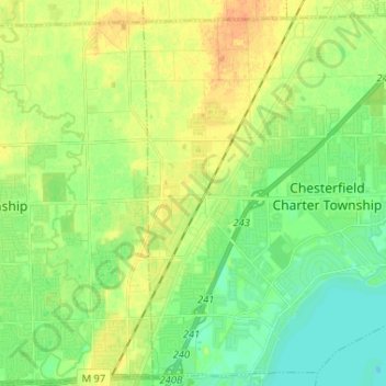
Name: Chesterfield Township topographic map, elevation, terrain.
Average elevation: 597 ft
Minimum elevation: 561 ft
Maximum elevation: 656 ft
Macomb County trails, hiking, mountain biking, running and outdoor activities
Make a donation
Gear up for your next adventure:
As an Amazon Associate, this site earns from qualifying purchases at no extra cost to you.
Other topographic maps
Click on a map to view its topography, its elevation and its terrain.
Anchor Bay Shores
United States > Michigan > Macomb County > Chesterfield Township
Average elevation: 577 ft
Preston Corners
United States > Michigan > Macomb County > Shelby Charter Township
Average elevation: 650 ft
Make a donation
Gear up for your next adventure:
As an Amazon Associate, this site earns from qualifying purchases at no extra cost to you.
Shelby Charter Township
United States > Michigan > Macomb County > Shelby Charter Township
Average elevation: 673 ft
Sterling Heights
United States > Michigan > Macomb County > Sterling Heights > Sterling Heights
Average elevation: 673 ft