
Wolverhampton topographic map
Interactive map
Click on the map to display elevation.
About this map
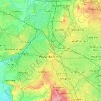
Name: Wolverhampton topographic map, elevation, terrain.
Average elevation: 453 ft
Minimum elevation: 262 ft
Maximum elevation: 774 ft
Other topographic maps
Click on a map to view its topography, its elevation and its terrain.
Wolverhampton
United Kingdom > England > West Midlands Combined Authority > Wolverhampton
Wolverhampton, West Midlands Combined Authority, West Midlands, England, WV1 3ET, United Kingdom
Average elevation: 407 ft
Goldthorn Park
United Kingdom > England > West Midlands Combined Authority > Wolverhampton > Goldthorn Park
Goldthorn Park, Wolverhampton, West Midlands Combined Authority, West Midlands, England, WV4 5BP, United Kingdom
Average elevation: 522 ft