
Upper Potomac River topographic map
Interactive map
Click on the map to display elevation.
About this map
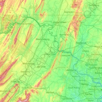
Name: Upper Potomac River topographic map, elevation, terrain.
Average elevation: 722 ft
Minimum elevation: 36 ft
Maximum elevation: 3,389 ft
Other topographic maps
Click on a map to view its topography, its elevation and its terrain.
Potomac River
United States of America > Maryland
Potomac River, Montgomery County, Maryland, 20566, United States of America
Average elevation: 469 ft
Chesapeake Bay
United States of America > Maryland
Chesapeake Bay, Dorchester County, Maryland, United States of America
Average elevation: 0 ft
Lower Potomac River
United States of America > Maryland
Lower Potomac River, Charles County, Maryland, 20566, United States of America
Average elevation: 128 ft
Williston Lake
United States of America > Maryland > Williston
Williston Lake, Williston Road, Williams Heights, Williston, Caroline County, Maryland, 21629, United States of America
Average elevation: 36 ft
Auth Village
United States of America > Maryland > Auth Village
Auth Village, Camp Springs, Prince George's County, Maryland, 20746, United States of America
Average elevation: 253 ft
Fairview
United States of America > Maryland > Fairview
Fairview, Burtonsville, Montgomery County, Maryland, 20866, United States of America
Average elevation: 443 ft
East Riverdale
United States of America > Maryland > East Riverdale
East Riverdale, Prince George's County, Maryland, 20737, United States of America
Average elevation: 118 ft
Wood Point
United States of America > Maryland > Wood Point
Wood Point, Washington County, Maryland, 21741, United States of America
Average elevation: 604 ft
Gunpowder
United States of America > Maryland
Gunpowder, Joppatowne, Harford County, Maryland, 21085, United States of America
Average elevation: 125 ft