
Kumtich topographic map
Interactive map
Click on the map to display elevation.
About this map
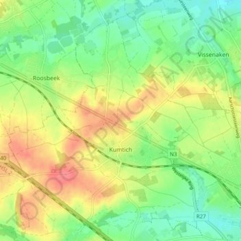
Name: Kumtich topographic map, elevation, terrain.
Location: Kumtich, Tienen, Vlaams-Brabant, Vlaanderen, België (50.80034 4.85161 50.84890 4.91405)
Average elevation: 210 ft
Minimum elevation: 118 ft
Maximum elevation: 322 ft
Other topographic maps
Click on a map to view its topography, its elevation and its terrain.
Oplinter
België > Vlaanderen > Tienen
Oplinter, Tienen, Vlaams-Brabant, Vlaanderen, België
Average elevation: 141 ft