
Au Sable River topographic map
Interactive map
Click on the map to display elevation.
About this map
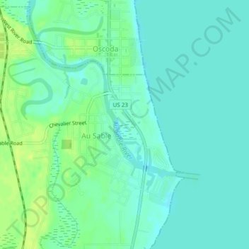
Name: Au Sable River topographic map, elevation, terrain.
Average elevation: 584 ft
Minimum elevation: 564 ft
Maximum elevation: 614 ft
Other topographic maps
Click on a map to view its topography, its elevation and its terrain.
Grosse Ile
États-Unis > Michigan > Grosse Ile
Grosse Ile, Grosse Ile Township, Wayne County, Michigan, 48138, États-Unis
Average elevation: 584 ft
Gun Lake
Gun Lake, Hastings Point Road, Yankee Springs Township, Barry County, Michigan, 49333, États-Unis
Average elevation: 768 ft
Ramsey Lake
Ramsey Lake, Dd Road, Nahma Township, Delta County, Michigan, États-Unis
Average elevation: 745 ft
Anchor Bay
États-Unis > Michigan > New Baltimore
Anchor Bay, Taylor Street, New Baltimore, Macomb County, Michigan, 48047, États-Unis
Average elevation: 568 ft