Geolocate

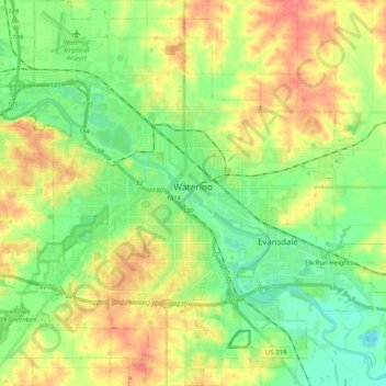
Waterloo topographic map

Click on the map to display elevation.

Waterloo

The average elevation of Waterloo is 846 feet above sea level. The population density is 1101 people per square mile, considered low for an urban area.

Wikipedia (CC-BY-SA 3.0)

About this map

Name: Waterloo topographic map, elevation, terrain.

Location: Waterloo, Black Hawk County, Iowa, United States (42.42116 -92.43682 42.57049 -92.24886)

Average elevation: 892 ft

Minimum elevation: 807 ft

Maximum elevation: 1,007 ft

Black Hawk County trails, hiking, mountain biking, running and outdoor activities

Other topographic maps

Click on a map to view its topography, its elevation and its terrain.
Washburn

United States > Iowa > Black Hawk County

Average elevation: 846 ft

Dewar

United States > Iowa > Black Hawk County

Average elevation: 915 ft

Jubilee

United States > Iowa > Black Hawk County

Average elevation: 883 ft

Gear up for your next adventure:

🧦Hiking Socks - Comfortable socks to prevent blisters on long hikes
🛰️Satellite Messengers - Emergency SOS and two-way messaging for off-grid adventures
🏕️Family Camping Gear - Essentials for group camping trips
🚪Portable Camp Chair - Foldable chair for comfort at camp
🎒Trekking Poles - Sturdy poles for balance and stability on rough terrain

As an Amazon Associate, this site earns from qualifying purchases at no extra cost to you.