
Grimming topographic map
Interactive map
Click on the map to display elevation.
About this map
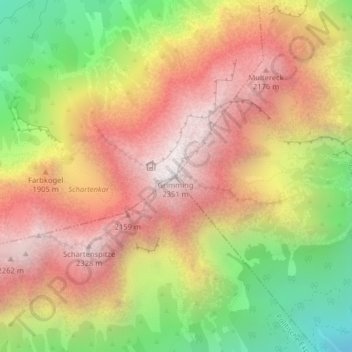
Name: Grimming topographic map, elevation, terrain.
Location: Grimming, Stainach-Pürgg, Liezen, Styria, 8950, Austria (47.52066 14.01717 47.52076 14.01727)
Average elevation: 5,495 ft
Minimum elevation: 2,792 ft
Maximum elevation: 7,671 ft
Other topographic maps
Click on a map to view its topography, its elevation and its terrain.
Spechtensee
Austria > Styria > Stainach-Pürgg
Spechtensee, Spechtenseerunde, Hechl, Stainach-Pürgg, Liezen, Styria, 8950, Austria
Average elevation: 3,904 ft