
Lake Lilla topographic map
Interactive map
Click on the map to display elevation.
About this map
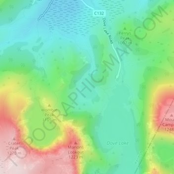
Name: Lake Lilla topographic map, elevation, terrain.
Average elevation: 3,310 ft
Minimum elevation: 2,851 ft
Maximum elevation: 4,219 ft
Other topographic maps
Click on a map to view its topography, its elevation and its terrain.
Cradle Mountain
Australia > Tasmania > Cradle Mountain
Cradle Mountain, Cradle Mount Summit Track, Cradle Mountain, Meander Valley, Tasmania, Australia
Average elevation: 3,753 ft
Dove Lake
Australia > Tasmania > Cradle Mountain
Dove Lake, Cradle Mountain, Kentish, Tasmania, Australia
Average elevation: 3,478 ft