
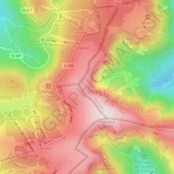
Falimont topographic map
Interactive map
Click on the map to display elevation.
About this map
Name: Falimont topographic map, elevation, terrain.
Average elevation: 3,753 ft
Minimum elevation: 2,762 ft
Maximum elevation: 4,436 ft
Other topographic maps
Click on a map to view its topography, its elevation and its terrain.
Réserve naturelle du Frankenthal-Missheimle
France > Grand Est > Stosswihr
Réserve naturelle du Frankenthal-Missheimle, Sentier de la Bloy, Stosswihr, Colmar-Ribeauvillé, Haut-Rhin, Grand Est, France métropolitaine, 68140, France
Average elevation: 3,291 ft
Lac de Schiessrothried
France > Grand Est > Stosswihr
Lac de Schiessrothried, Sentier des Couloirs, Stosswihr, Colmar-Ribeauvillé, Haut-Rhin, Grand Est, France métropolitaine, 68140, France
Average elevation: 3,524 ft
La Grotte Dagobert
France > Grand Est > Stosswihr
La Grotte Dagobert, Sentier des Couloirs, Stosswihr, Colmar-Ribeauvillé, Haut-Rhin, Grand Est, France métropolitaine, 68140, France
Average elevation: 3,678 ft
Petit Cervin
France > Grand Est > Stosswihr
Petit Cervin, Sentier du Falimont, Stosswihr, Colmar-Ribeauvillé, Haut-Rhin, Grand Est, France métropolitaine, 68140, France
Average elevation: 3,711 ft