
Tsiroanomandidy topographic map
Interactive map
Click on the map to display elevation.
About this map
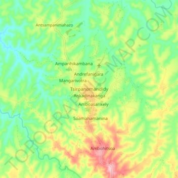
Name: Tsiroanomandidy topographic map, elevation, terrain.
Average elevation: 2,710 ft
Minimum elevation: 2,500 ft
Maximum elevation: 3,038 ft
Other topographic maps
Click on a map to view its topography, its elevation and its terrain.
Ambohijanahary
Madagascar > Bongolava > Ambohijanahary
Ambohijanahary, Bongolava, Province d’Antananarivo, Madagascar
Average elevation: 2,293 ft