
Make a donation
Gear up for your next adventure:
As an Amazon Associate, this site earns from qualifying purchases at no extra cost to you.
Pagadian topographic map
Click on the map to display elevation.
Make a donation
Gear up for your next adventure:
As an Amazon Associate, this site earns from qualifying purchases at no extra cost to you.
Pagadian
About 45% of the total city area is steeply sloping terrain of hills and mountains on the northwestern portion that covers an estimated 15,090 hectares. Mt. Sugarloaf (1,376 m.), Mt. Pinukis (1,213 m.), and Mt. Palpalan (650 m.) are the three notable mountain peaks. Areas in the direct north and central part, have gentle to moderate slopes, making up 47% of the total. The remaining 8% is level or nearly level which makes up most of the eastern and the southern parts of the city. The urban area covers about 845.48 hectares. Elevation of the urban area of the city ranges from 1 MSL (mean sea level) near Pagadian Bay to about 100 MSL in the area of Barangay San Jose.
Make a donation
Gear up for your next adventure:
As an Amazon Associate, this site earns from qualifying purchases at no extra cost to you.
About this map
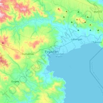
Name: Pagadian topographic map, elevation, terrain.
Average elevation: 554 ft
Minimum elevation: -3 ft
Maximum elevation: 2,946 ft
Make a donation
Gear up for your next adventure:
As an Amazon Associate, this site earns from qualifying purchases at no extra cost to you.
Other topographic maps
Click on a map to view its topography, its elevation and its terrain.