Geolocate

马场镇 topographic map

Interactive map

Click on the map to display elevation.

About this map

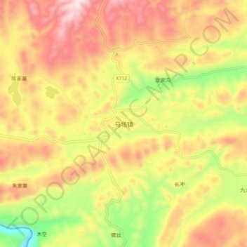
Name: 马场镇 topographic map, elevation, terrain.

Location: 马场镇, 大方县, 毕节市, 贵州省, 中国 (26.90776 105.44786 26.98776 105.52786)

Average elevation: 4,954 ft

Minimum elevation: 3,661 ft

Maximum elevation: 6,056 ft

Other topographic maps

Click on a map to view its topography, its elevation and its terrain.

锅厂

中国 > 贵州省 > 大方县

锅厂, 大方县, 毕节市, 贵州省, 中国

Average elevation: 5,049 ft

新基

中国 > 贵州省 > 大方县

新基, 大方县, 毕节市, 贵州省, 中国

Average elevation: 4,908 ft

凤山乡

中国 > 贵州省 > 大方县

凤山乡, 大方县, 毕节市, 贵州省, 中国

Average elevation: 5,636 ft

大方县

中国 > 贵州省 > 大方县 > 红旗

大方县, 红旗, 大方县, 毕节市, 贵州省, 中国

Average elevation: 5,112 ft

海坝

中国 > 贵州省 > 大方县

海坝, 大方县, 毕节市, 贵州省, 中国

Average elevation: 5,469 ft