
Le Grand Colombier topographic map
Interactive map
Click on the map to display elevation.
About this map
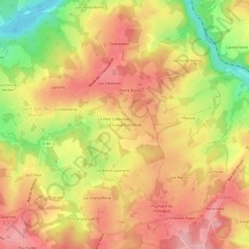
Name: Le Grand Colombier topographic map, elevation, terrain.
Average elevation: 1,056 ft
Minimum elevation: 748 ft
Maximum elevation: 1,260 ft
Other topographic maps
Click on a map to view its topography, its elevation and its terrain.
Bambournet
France > Nouvelle-Aquitaine > Haute-Vienne > Saint-Just-le-Martel
Bambournet, Saint-Just-le-Martel, Limoges, Haute-Vienne, Nouvelle-Aquitaine, France métropolitaine, 87590, France
Average elevation: 1,191 ft
Les Clédières
France > Nouvelle-Aquitaine > Haute-Vienne > Saint-Just-le-Martel > Les Clédières
Les Clédières, Saint-Just-le-Martel, Limoges, Haute-Vienne, Nouvelle-Aquitaine, France métropolitaine, 87590, France
Average elevation: 1,014 ft