
North Frankfort topographic map
Interactive map
Click on the map to display elevation.
About this map
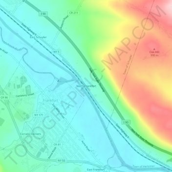
Name: North Frankfort topographic map, elevation, terrain.
Average elevation: 581 ft
Minimum elevation: 354 ft
Maximum elevation: 1,106 ft
Other topographic maps
Click on a map to view its topography, its elevation and its terrain.
West Schuyler
United States > New York > Herkimer County > Town of Schuyler
West Schuyler, Town of Schuyler, Herkimer County, New York, 13504, United States
Average elevation: 472 ft
Johnson Corners
United States > New York > Herkimer County > Town of Schuyler
Johnson Corners, Town of Schuyler, Herkimer County, New York, United States
Average elevation: 755 ft
Baker Corners
United States > New York > Herkimer County > Town of Schuyler
Baker Corners, Town of Schuyler, Herkimer County, New York, 13504, United States
Average elevation: 594 ft
East Schuyler
United States > New York > Herkimer County > Town of Schuyler
East Schuyler, Town of Schuyler, Herkimer County, New York, 13340, United States
Average elevation: 522 ft