
Make a donation
Gear up for your next adventure:
As an Amazon Associate, this site earns from qualifying purchases at no extra cost to you.
Aventura topographic map
Click on the map to display elevation.
Make a donation
Gear up for your next adventure:
As an Amazon Associate, this site earns from qualifying purchases at no extra cost to you.
Aventura
In addition to its sea-level elevation, coastal location and position just north of the Tropic of Cancer, the area owes its warm, humid climate to the Gulf Stream, which moderates climate year-round. A typical summer day does not see temperatures below 75 °F (24 °C). Temperatures in the high 80s to low 90s (30–35 °C) accompanied by high humidity are often relieved by afternoon thunderstorms or a sea breeze that develops off the Atlantic Ocean, which then allow lower temperatures, although conditions still remain very muggy. During winter, humidity is significantly lower, allowing for cooler weather to develop. Average minimum temperatures during that time are around 59 °F (15 °C), rarely dipping below 40 °F (4 °C), and the equivalent maxima usually around 75 °F (24 °C).
Make a donation
Gear up for your next adventure:
As an Amazon Associate, this site earns from qualifying purchases at no extra cost to you.
About this map
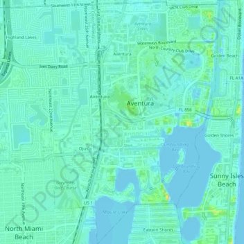
Name: Aventura topographic map, elevation, terrain.
Location: Aventura, Miami-Dade County, Florida, United States (25.93109 -80.15032 25.97505 -80.12331)
Average elevation: 23 ft
Minimum elevation: -7 ft
Maximum elevation: 118 ft
Miami-Dade County trails, hiking, mountain biking, running and outdoor activities
Make a donation
Gear up for your next adventure:
As an Amazon Associate, this site earns from qualifying purchases at no extra cost to you.
Other topographic maps
Click on a map to view its topography, its elevation and its terrain.
Key Biscayne
United States > Florida > Miami-Dade County
Key Biscayne lies south of Miami Beach and east of Miami. The village is connected to Miami via the Rickenbacker Causeway, originally built in 1947. Because of its low elevation and direct exposure to the Atlantic Ocean, it is usually among the first Miami areas to be evacuated before an oncoming hurricane.
Average elevation: 10 ft
Bal Harbor Beach
United States > Florida > Miami-Dade County > Bal Harbour Village
Average elevation: 10 ft
Make a donation
Gear up for your next adventure:
As an Amazon Associate, this site earns from qualifying purchases at no extra cost to you.
Silver Court Trailer Park
United States > Florida > Miami-Dade County > Miami
Average elevation: 30 ft
Make a donation
Gear up for your next adventure:
As an Amazon Associate, this site earns from qualifying purchases at no extra cost to you.
Virginia Key Beach North Point Park
United States > Florida > Miami-Dade County > Miami
Average elevation: 10 ft
Make a donation
Gear up for your next adventure:
As an Amazon Associate, this site earns from qualifying purchases at no extra cost to you.
Hibiscus Point Mobile Home Park
United States > Florida > Miami-Dade County > Hialeah
Average elevation: 26 ft
Harris Field
United States > Florida > Miami-Dade County > Homestead > Four Seasons Mobile Home Park
Average elevation: 13 ft
Make a donation
Gear up for your next adventure:
As an Amazon Associate, this site earns from qualifying purchases at no extra cost to you.
Medley Lakeside Retirement Community
United States > Florida > Miami-Dade County > Medley
Average elevation: 20 ft
Make a donation
Gear up for your next adventure:
As an Amazon Associate, this site earns from qualifying purchases at no extra cost to you.
Andover Golf Estates
United States > Florida > Miami-Dade County > Miami Gardens
Average elevation: 23 ft
Miami
United States > Florida > Miami-Dade County
Miami and its suburbs are located on a broad plain between the Everglades to the west and Biscayne Bay to the east, which extends from Lake Okeechobee southward to Florida Bay. The elevation of the area averages at around 6 ft (1.8 m) above sea level in most neighborhoods, especially near the coast. The…
Average elevation: 13 ft
Make a donation
Gear up for your next adventure:
As an Amazon Associate, this site earns from qualifying purchases at no extra cost to you.
Cloverleaf Park
United States > Florida > Miami-Dade County > Miami Gardens > Norland
Average elevation: 26 ft
Goldcoaster Mobile Home Park
United States > Florida > Miami-Dade County > Homestead
Average elevation: 10 ft
Make a donation
Gear up for your next adventure:
As an Amazon Associate, this site earns from qualifying purchases at no extra cost to you.
Strawberry Village Trailer Park
United States > Florida > Miami-Dade County > Hialeah
Average elevation: 20 ft
West Little River
United States > Florida > Miami-Dade County > Miami > West Little River
Average elevation: 23 ft
Make a donation
Gear up for your next adventure:
As an Amazon Associate, this site earns from qualifying purchases at no extra cost to you.
Aquarius Mobile Home Park
United States > Florida > Miami-Dade County > Homestead
Average elevation: 13 ft
Make a donation
Gear up for your next adventure:
As an Amazon Associate, this site earns from qualifying purchases at no extra cost to you.
Baywinds Apartments
United States > Florida > Miami-Dade County > North Miami
Average elevation: 23 ft
Harbor Island
United States > Florida > Miami-Dade County > North Bay Village
Average elevation: 10 ft
Make a donation
Gear up for your next adventure:
As an Amazon Associate, this site earns from qualifying purchases at no extra cost to you.
Make a donation
Gear up for your next adventure:
As an Amazon Associate, this site earns from qualifying purchases at no extra cost to you.
Make a donation
Gear up for your next adventure:
As an Amazon Associate, this site earns from qualifying purchases at no extra cost to you.
Bal Harbor Beach
United States > Florida > Miami-Dade County > Bal Harbour Village
Average elevation: 10 ft
Make a donation
Gear up for your next adventure:
As an Amazon Associate, this site earns from qualifying purchases at no extra cost to you.
Make a donation
Gear up for your next adventure:
As an Amazon Associate, this site earns from qualifying purchases at no extra cost to you.
Strawberry Village Trailer Park
United States > Florida > Miami-Dade County > Hialeah
Average elevation: 20 ft
Make a donation
Gear up for your next adventure:
As an Amazon Associate, this site earns from qualifying purchases at no extra cost to you.
West Little River
United States > Florida > Miami-Dade County > West Little River
Average elevation: 23 ft
South Miami Heights
United States > Florida > Miami-Dade County > South Miami Heights
Average elevation: 20 ft
Make a donation
Gear up for your next adventure:
As an Amazon Associate, this site earns from qualifying purchases at no extra cost to you.
Silver Court Trailer Park
United States > Florida > Miami-Dade County > Miami
Average elevation: 30 ft