
Vultare topographic map
Interactive map
Click on the map to display elevation.
About this map
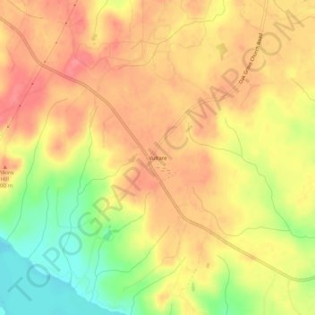
Name: Vultare topographic map, elevation, terrain.
Location: Vultare, Northampton County, North Carolina, United States (36.49709 -77.78498 36.53709 -77.74498)
Average elevation: 276 ft
Minimum elevation: 125 ft
Maximum elevation: 364 ft
Other topographic maps
Click on a map to view its topography, its elevation and its terrain.
Woodland
United States > North Carolina > Northampton County
Woodland, Northampton County, North Carolina, 27897, United States
Average elevation: 62 ft