
Dößel topographic map
Interactive map
Click on the map to display elevation.
About this map
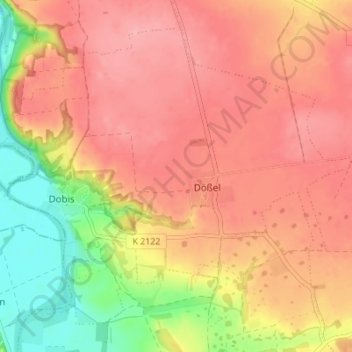
Name: Dößel topographic map, elevation, terrain.
Location: Dößel, Wettin-Löbejün, Saalekreis, Sachsen-Anhalt, Deutschland (51.59891 11.75188 51.63486 11.82067)
Average elevation: 427 ft
Minimum elevation: 200 ft
Maximum elevation: 554 ft
Other topographic maps
Click on a map to view its topography, its elevation and its terrain.
Lettewitz
Deutschland > Sachsen-Anhalt > Saalekreis > Wettin-Löbejün
Lettewitz, Wettin-Löbejün, Saalekreis, Sachsen-Anhalt, Deutschland
Average elevation: 463 ft
Wettin
Deutschland > Sachsen-Anhalt > Saalekreis > Wettin-Löbejün
Wettin, Wettin-Löbejün, Saalekreis, Sachsen-Anhalt, Deutschland
Average elevation: 377 ft
Löbejün
Deutschland > Sachsen-Anhalt > Saalekreis > Wettin-Löbejün
Löbejün, Wettin-Löbejün, Saalekreis, Sachsen-Anhalt, Deutschland
Average elevation: 364 ft