
Lostallo topographic map
Interactive map
Click on the map to display elevation.
About this map
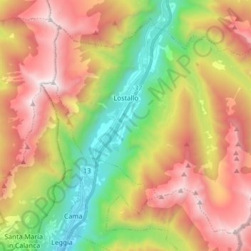
Name: Lostallo topographic map, elevation, terrain.
Location: Lostallo, Moësa, Graubünden, 6558, Schweiz (46.26600 9.15910 46.34076 9.28505)
Average elevation: 4,682 ft
Minimum elevation: 1,073 ft
Maximum elevation: 8,684 ft
Other topographic maps
Click on a map to view its topography, its elevation and its terrain.
Logiano
Schweiz > Graubünden > Moësa > Misox
Logiano, Misox, Moësa, Graubünden, 6563, Schweiz
Average elevation: 4,383 ft