
Saint-Martin-de-Belleville topographic map
Interactive map
Click on the map to display elevation.
About this map
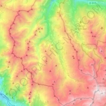
Name: Saint-Martin-de-Belleville topographic map, elevation, terrain.
Average elevation: 6,526 ft
Minimum elevation: 1,709 ft
Maximum elevation: 11,591 ft
Other topographic maps
Click on a map to view its topography, its elevation and its terrain.
Hameau des Marmottes
Frankrijk > Auvergne-Rhône-Alpes > Les Belleville > Hameau des Marmottes
Hameau des Marmottes, Saint-Martin-de-Belleville, Les Belleville, Albertville, Savoie, Auvergne-Rhône-Alpes, Metropolitaans Frankrijk, 73440, Frankrijk
Average elevation: 6,617 ft