
Manderscheid topographic map
Interactive map
Click on the map to display elevation.
About this map
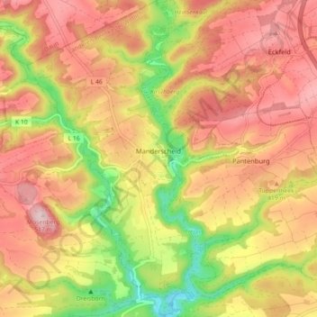
Name: Manderscheid topographic map, elevation, terrain.
Average elevation: 1,293 ft
Minimum elevation: 817 ft
Maximum elevation: 1,640 ft
Other topographic maps
Click on a map to view its topography, its elevation and its terrain.
Piesport
Allemagne > Rhénanie-Palatinat > Landkreis Bernkastel-Wittlich
Piesport, Bernkastel-Kues, Landkreis Bernkastel-Wittlich, Rhénanie-Palatinat, 54498, Allemagne
Average elevation: 807 ft
Kautenbach
Allemagne > Rhénanie-Palatinat > Landkreis Bernkastel-Wittlich > Traben-Trarbach > Kautenbach
Kautenbach, Traben-Trarbach, Landkreis Bernkastel-Wittlich, Rhénanie-Palatinat, 56841, Allemagne
Average elevation: 1,132 ft