
元墩镇 topographic map
Interactive map
Click on the map to display elevation.
About this map
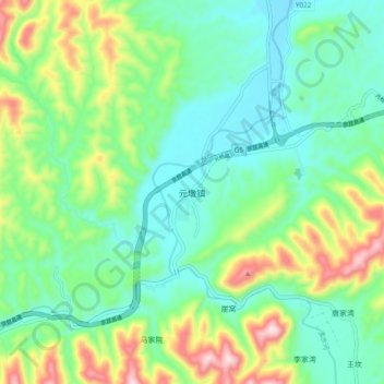
Name: 元墩镇 topographic map, elevation, terrain.
Location: 元墩镇, 勉县, 汉中市, 陕西省, 中国 (33.01442 106.61191 33.09442 106.69191)
Average elevation: 2,270 ft
Minimum elevation: 1,837 ft
Maximum elevation: 3,314 ft
Other topographic maps
Click on a map to view its topography, its elevation and its terrain.