
Parada de Pinhão topographic map
Interactive map
Click on the map to display elevation.
About this map
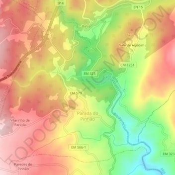
Name: Parada de Pinhão topographic map, elevation, terrain.
Location: Parada de Pinhão, Sabrosa, Vila Real, Portugal (41.32634 -7.61722 41.35511 -7.57351)
Average elevation: 2,041 ft
Minimum elevation: 1,470 ft
Maximum elevation: 2,480 ft
Other topographic maps
Click on a map to view its topography, its elevation and its terrain.
Vale das Gatas
Portugal > Vila Real > Sabrosa > São Lourenço de Ribapinhão
Vale das Gatas, São Lourenço de Ribapinhão, Sabrosa, Vila Real, 5060-322, Portugal
Average elevation: 1,982 ft