
San Rafael topographic map
Interactive map
Click on the map to display elevation.
About this map
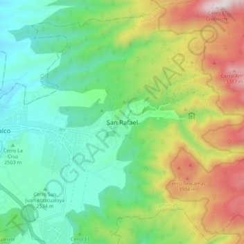
Name: San Rafael topographic map, elevation, terrain.
Location: San Rafael, Tlalmanalco, Estado de México, 56740, México (19.16944 -98.79706 19.24944 -98.71706)
Average elevation: 8,934 ft
Minimum elevation: 7,677 ft
Maximum elevation: 11,404 ft
Other topographic maps
Click on a map to view its topography, its elevation and its terrain.
Parque Nacional Iztaccíhuatl-Popocatépetl
México > Estado de México > Tlalmanalco
Parque Nacional Iztaccíhuatl-Popocatépetl, Tlalmanalco, Estado de México, México
Average elevation: 8,743 ft