
Rootok Island topographic map
Interactive map
Click on the map to display elevation.
About this map
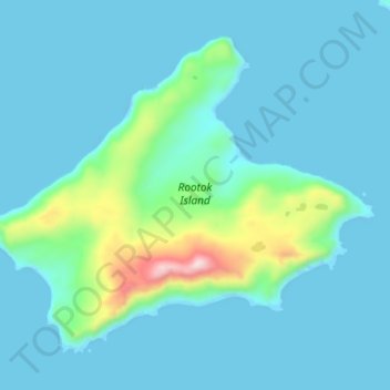
Name: Rootok Island topographic map, elevation, terrain.
Location: Rootok Island, Aleutians East, Alaska, United States (54.02390 -165.57346 54.06719 -165.48261)
Average elevation: 197 ft
Minimum elevation: -46 ft
Maximum elevation: 1,509 ft
Other topographic maps
Click on a map to view its topography, its elevation and its terrain.
Cold Bay
United States > Alaska > Aleutians East
Cold Bay, Aleutians East, Alaska, 99571, United States
Average elevation: 203 ft
Sand Point
United States > Alaska > Aleutians East > Sand Point
Sand Point, Aleutians East, Alaska, 99661, United States
Average elevation: 128 ft