
Thank you for supporting this site ❤️
Make a donation
Make a donation
Gear up for your next adventure:
As an Amazon Associate, this site earns from qualifying purchases at no extra cost to you.
Soca topographic map
Click on the map to display elevation.
Thank you for supporting this site ❤️
Make a donation
Make a donation
Gear up for your next adventure:
As an Amazon Associate, this site earns from qualifying purchases at no extra cost to you.
About this map
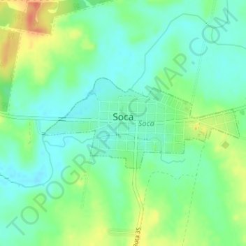
Name: Soca topographic map, elevation, terrain.
Location: Soca, Canelones, 91006, Uruguay (-34.68912 -55.71500 -34.67920 -55.68894)
Average elevation: 59 ft
Minimum elevation: 7 ft
Maximum elevation: 148 ft
Thank you for supporting this site ❤️
Make a donation
Make a donation
Gear up for your next adventure:
As an Amazon Associate, this site earns from qualifying purchases at no extra cost to you.
Other topographic maps
Click on a map to view its topography, its elevation and its terrain.
Manzana 9190
Uruguay > Canelones > Municipio de Ciudad de la Costa > Ciudad de la Costa
Average elevation: 33 ft