
Villa Mañihuales topographic map
Interactive map
Click on the map to display elevation.
About this map
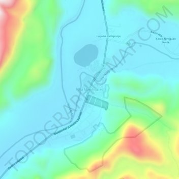
Name: Villa Mañihuales topographic map, elevation, terrain.
Average elevation: 869 ft
Minimum elevation: 407 ft
Maximum elevation: 2,585 ft
Other topographic maps
Click on a map to view its topography, its elevation and its terrain.
Puerto Chacabuco
Chile > Región Aysén del General Carlos Ibáñez del Campo > Provincia de Aysén > Aysén
Puerto Chacabuco, Aysén, Provincia de Aysén, Región Aysén del General Carlos Ibáñez del Campo, Chile
Average elevation: 705 ft