
Make a donation
Gear up for your next adventure:
As an Amazon Associate, this site earns from qualifying purchases at no extra cost to you.
Копыл topographic map
Click on the map to display elevation.
Make a donation
Gear up for your next adventure:
As an Amazon Associate, this site earns from qualifying purchases at no extra cost to you.
Копыл
Село находится в северной части Воронежской области, в лесостепной зоне, в пределах Окско-Донской равнины, на левом берегу реки Токай, на расстоянии примерно 23 километров (по прямой) к юго-востоку от города Эртиль, административного центра района. Абсолютная высота — 146 метров над уровнем моря.
Make a donation
Gear up for your next adventure:
As an Amazon Associate, this site earns from qualifying purchases at no extra cost to you.
About this map
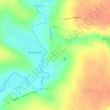
Name: Копыл topographic map, elevation, terrain.
Average elevation: 482 ft
Minimum elevation: 407 ft
Maximum elevation: 561 ft
Make a donation
Gear up for your next adventure:
As an Amazon Associate, this site earns from qualifying purchases at no extra cost to you.
Other topographic maps
Click on a map to view its topography, its elevation and its terrain.