
Make a donation
Gear up for your next adventure:
As an Amazon Associate, this site earns from qualifying purchases at no extra cost to you.
Plaistow topographic map
Click on the map to display elevation.
Make a donation
Gear up for your next adventure:
As an Amazon Associate, this site earns from qualifying purchases at no extra cost to you.
About this map
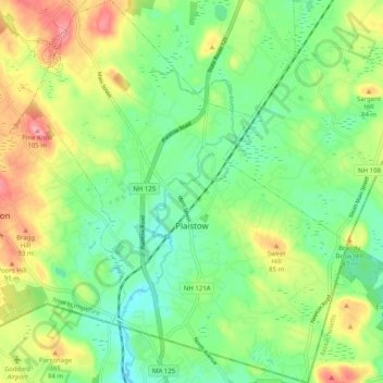
Name: Plaistow topographic map, elevation, terrain.
Average elevation: 157 ft
Minimum elevation: 20 ft
Maximum elevation: 381 ft
Rockingham County trails, hiking, mountain biking, running and outdoor activities
Make a donation
Gear up for your next adventure:
As an Amazon Associate, this site earns from qualifying purchases at no extra cost to you.
Other topographic maps
Click on a map to view its topography, its elevation and its terrain.
Make a donation
Gear up for your next adventure:
As an Amazon Associate, this site earns from qualifying purchases at no extra cost to you.
South Beacon Shoal
United States > New Hampshire > Rockingham County > Portsmouth
Average elevation: 13 ft
Hampton River
United States > New Hampshire > Rockingham County > Hampton Falls
Average elevation: 3 ft
Make a donation
Gear up for your next adventure:
As an Amazon Associate, this site earns from qualifying purchases at no extra cost to you.
Providence Hill
United States > New Hampshire > Rockingham County > Atkinson
Average elevation: 236 ft
Make a donation
Gear up for your next adventure:
As an Amazon Associate, this site earns from qualifying purchases at no extra cost to you.
Rye Beach Village District
United States > New Hampshire > Rockingham County > Rye Beach Village District
Average elevation: 23 ft
Salem Depot
United States > New Hampshire > Rockingham County > Salem > Salem Depot
Average elevation: 164 ft
Make a donation
Gear up for your next adventure:
As an Amazon Associate, this site earns from qualifying purchases at no extra cost to you.