
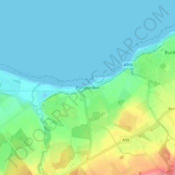
Portgordon topographic map
Interactive map
Click on the map to display elevation.
About this map
Name: Portgordon topographic map, elevation, terrain.
Location: Portgordon, Moray, Écosse, AB56 5TL, Royaume-Uni (57.64349 -3.03604 57.68349 -2.99604)
Average elevation: 72 ft
Minimum elevation: -7 ft
Maximum elevation: 292 ft
Other topographic maps
Click on a map to view its topography, its elevation and its terrain.
Alves
Royaume-Uni > Écosse > Moray
Alves, Moray, Écosse, IV30 8UT, Royaume-Uni
Average elevation: 108 ft
Aberlour
Royaume-Uni > Écosse > Moray > Aberlour
Aberlour, Moray, Écosse, AB38 9PX, Royaume-Uni
Average elevation: 525 ft
Glenlivet
Royaume-Uni > Écosse > Moray > Glenlivet
Glenlivet, Moray, Écosse, AB37 9BT, Royaume-Uni
Average elevation: 919 ft