Geolocate

Roebuck topographic map

Click on the map to display elevation.

About this map

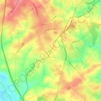
Name: Roebuck topographic map, elevation, terrain.

Location: Roebuck, Spartanburg County, South Carolina, United States (34.85901 -81.98633 34.90618 -81.93819)

Average elevation: 735 ft

Minimum elevation: 574 ft

Maximum elevation: 856 ft

Spartanburg County trails, hiking, mountain biking, running and outdoor activities

Gear up for your next adventure:

🌡️Portable Weather Meter - Track weather conditions on the trail
🥾Men's Hiking Boots - Durable, waterproof footwear for rugged terrain and steep inclines
💧Water Filtration Bottles - Safely drink from streams and lakes while exploring
🩳Quick‑Dry Hiking Shorts - Comfortable and quick‑dry shorts for summer hiking
☀️Outdoor Sunscreen - High protection sunscreen for outdoor activities

As an Amazon Associate, this site earns from qualifying purchases at no extra cost to you.