Geolocate

Puri topographic map

Click on the map to display elevation.

About this map

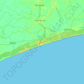
Name: Puri topographic map, elevation, terrain.

Location: Puri, Puri (M), Puri, Odisha, 752001, India (19.64761 85.66525 19.96761 85.98525)

Average elevation: 13 ft

Minimum elevation: -7 ft

Maximum elevation: 82 ft

Other topographic maps

Click on a map to view its topography, its elevation and its terrain.

Puri

India > Odisha > Puri (M)

Average elevation: 20 ft

Puri

India > Odisha > Puri (M)

Average elevation: 20 ft

Puri

India > Odisha > Puri (M)

Average elevation: 20 ft

Gear up for your next adventure:

🥇GPS Hiking Watch - Multi‑sport GPS watch with navigation and trail tracking
🪶Survival Guide Book - Expert advice for emergency preparedness
🌲Outdoor Survival Books - Best books on survival skills
🔭Stargazing Telescopes - Perfect for camping in low-light pollution areas shown on maps
🧼Biodegradable Camping Soap - Eco‑friendly soap for outdoor hygiene

As an Amazon Associate, this site earns from qualifying purchases at no extra cost to you.