
Mezouara topographic map
Interactive map
Click on the map to display elevation.
About this map
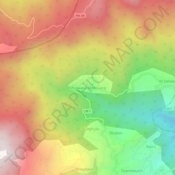
Name: Mezouara topographic map, elevation, terrain.
Location: Mezouara, Akfadou, Daïra Chemini, Béjaïa, 06411, Algérie (36.63076 4.58508 36.67076 4.62508)
Average elevation: 3,537 ft
Minimum elevation: 1,775 ft
Maximum elevation: 5,138 ft
Other topographic maps
Click on a map to view its topography, its elevation and its terrain.
Tiniri
Algérie > Béjaïa > Daïra Chemini > Akfadou
Tiniri, Akfadou, Daïra Chemini, Béjaïa, 06411, Algérie
Average elevation: 2,881 ft
Ziwi
Algérie > Béjaïa > Daïra Chemini > Akfadou
Ziwi, Akfadou, Daïra Chemini, Béjaïa, 06411, Algérie
Average elevation: 3,320 ft