
Urigoiti topographic map
Interactive map
Click on the map to display elevation.
About this map
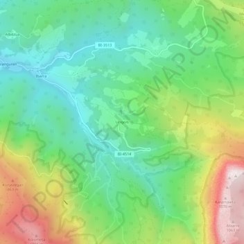
Name: Urigoiti topographic map, elevation, terrain.
Location: Urigoiti, Orozco, Vizcaya, País Vasco, 48419, España (43.06731 -2.86375 43.10731 -2.82375)
Average elevation: 1,693 ft
Minimum elevation: 709 ft
Maximum elevation: 3,573 ft
Other topographic maps
Click on a map to view its topography, its elevation and its terrain.
Parque Natural del Gorbea
España > País Vasco > Orozco
Parque Natural del Gorbea, Orozco, Vizcaya, País Vasco, 48410, España
Average elevation: 2,008 ft
Altube
España > País Vasco > Orozco
Altube, Orozco, Arratia-Nervión, Vizcaya, País Vasco, 48410, España
Average elevation: 951 ft