
Corberrie topographic map
Interactive map
Click on the map to display elevation.
About this map
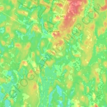
Name: Corberrie topographic map, elevation, terrain.
Average elevation: 246 ft
Minimum elevation: 164 ft
Maximum elevation: 381 ft
Other topographic maps
Click on a map to view its topography, its elevation and its terrain.
Haines Lake
Canada > Nova Scotia > Digby County > North Range
Haines Lake, North Range, Digby Municipal District, Digby County, Nova Scotia, B0W 1H0, Canada
Average elevation: 341 ft
Freeport
Canada > Nova Scotia > Digby County
Freeport, Digby Municipal District, Digby County, Nova Scotia, B0V 1B0, Canada
Average elevation: 23 ft
Briar Lake
Canada > Nova Scotia > Digby County
Briar Lake, Clare Municipal District, Digby County, Nova Scotia, Canada
Average elevation: 220 ft