
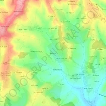
Le Brûlé topographic map
Interactive map
Click on the map to display elevation.
About this map
Name: Le Brûlé topographic map, elevation, terrain.
Average elevation: 614 ft
Minimum elevation: 436 ft
Maximum elevation: 833 ft
Other topographic maps
Click on a map to view its topography, its elevation and its terrain.
Préaux-du-Perche
France > Normandie > Orne > Perche en Nocé
Préaux-du-Perche, Perche en Nocé, Mortagne-au-Perche, Orne, Normandie, France métropolitaine, 61340, France
Average elevation: 482 ft
Le Rosier
France > Normandie > Orne > Perche en Nocé
Le Rosier, Préaux-du-Perche, Perche en Nocé, Mortagne-au-Perche, Orne, Normandie, France métropolitaine, 61340, France
Average elevation: 518 ft
Dancé
France > Normandie > Orne > Perche en Nocé
Dancé, Perche en Nocé, Mortagne-au-Perche, Orne, Normandie, France métropolitaine, 61340, France
Average elevation: 482 ft
Saint-Aubin-des-Grois
France > Normandie > Orne > Perche en Nocé
Saint-Aubin-des-Grois, Perche en Nocé, Mortagne-au-Perche, Orne, Normandie, France métropolitaine, 61340, France
Average elevation: 535 ft
Saint-Jean-de-la-Forêt
France > Normandie > Orne > Perche en Nocé
Saint-Jean-de-la-Forêt, Perche en Nocé, Mortagne-au-Perche, Orne, Normandie, France métropolitaine, 61340, France
Average elevation: 643 ft