
Lütgendortmund-Ost topographic map
Interactive map
Click on the map to display elevation.
About this map
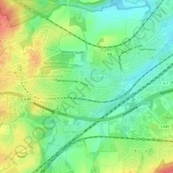
Name: Lütgendortmund-Ost topographic map, elevation, terrain.
Location: Lütgendortmund-Ost, Dortmund, North Rhine-Westphalia, Germany (51.49228 7.33560 51.50381 7.38075)
Average elevation: 315 ft
Minimum elevation: 233 ft
Maximum elevation: 430 ft
Other topographic maps
Click on a map to view its topography, its elevation and its terrain.
Freibad Froschloch
Germany > North Rhine-Westphalia > Dortmund
Freibad Froschloch, 103, Löttringhauser Straße, Löttringhausen, Hombruch, Dortmund, North Rhine-Westphalia, 44225, Germany
Average elevation: 364 ft
Westfalenpark
Germany > North Rhine-Westphalia > Dortmund
Westfalenpark, Mitte, Dortmund, Regierungsbezirk Arnsberg, North Rhine-Westphalia, 44139, Germany
Average elevation: 361 ft
Phoenix-See
Germany > North Rhine-Westphalia > Dortmund
Phoenix-See, Phoenixseestraße, Hörde, Dortmund, Regierungsbezirk Arnsberg, North Rhine-Westphalia, 44263, Germany
Average elevation: 381 ft