
La Croix aux Loups topographic map
Interactive map
Click on the map to display elevation.
About this map
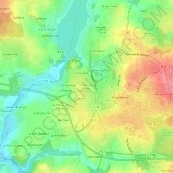
Name: La Croix aux Loups topographic map, elevation, terrain.
Average elevation: 190 ft
Minimum elevation: 72 ft
Maximum elevation: 335 ft
Other topographic maps
Click on a map to view its topography, its elevation and its terrain.
Le Clos Hazel
France > Brittany > Morbihan > Ploërmel
Le Clos Hazel, Ploërmel, Pontivy, Morbihan, Brittany, Metropolitan France, 56800, France
Average elevation: 194 ft