
Ibri topographic map
Interactive map
Click on the map to display elevation.
About this map
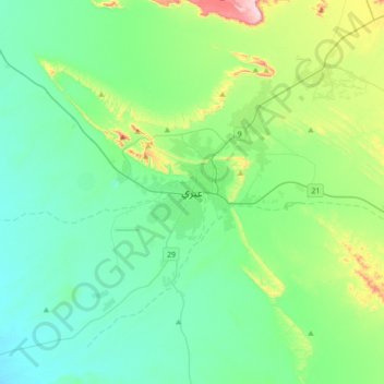
Name: Ibri topographic map, elevation, terrain.
Location: Ibri, Ad Dhahirah Governorate, Oman (23.05787 56.33219 23.37787 56.65219)
Average elevation: 1,191 ft
Minimum elevation: 883 ft
Maximum elevation: 2,392 ft
Other topographic maps
Click on a map to view its topography, its elevation and its terrain.
Al Fida
Oman > Ad Dhahirah Governorate
Al Fida, Ad Dhahirah Governorate, Oman
Average elevation: 1,880 ft