
Exton topographic map
Click on the map to display elevation.
About this map
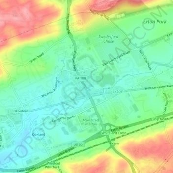
Name: Exton topographic map, elevation, terrain.
Average elevation: 387 ft
Minimum elevation: 259 ft
Maximum elevation: 604 ft
Chester County trails, hiking, mountain biking, running and outdoor activities
Other topographic maps
Click on a map to view its topography, its elevation and its terrain.
Whiteland Crest
United States > Pennsylvania > Chester County > West Whiteland Township > Exton
Average elevation: 417 ft