
Make a donation
Gear up for your next adventure:
As an Amazon Associate, this site earns from qualifying purchases at no extra cost to you.
New Lenox topographic map
Click on the map to display elevation.
Make a donation
Gear up for your next adventure:
As an Amazon Associate, this site earns from qualifying purchases at no extra cost to you.
New Lenox
New Lenox features the Sanctuary Golf Course. Bordering the west end of New Lenox and Joliet is Woodruff Golf Course. Opened in 1926, Woodruff is a course with sweeping elevation changes and small greens.
Make a donation
Gear up for your next adventure:
As an Amazon Associate, this site earns from qualifying purchases at no extra cost to you.
About this map
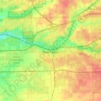
Name: New Lenox topographic map, elevation, terrain.
Location: New Lenox, Will County, Illinois, 60451, United States (41.46077 -88.02610 41.56651 -87.90743)
Average elevation: 686 ft
Minimum elevation: 581 ft
Maximum elevation: 778 ft
Will County trails, hiking, mountain biking, running and outdoor activities
Make a donation
Gear up for your next adventure:
As an Amazon Associate, this site earns from qualifying purchases at no extra cost to you.
Other topographic maps
Click on a map to view its topography, its elevation and its terrain.
Make a donation
Gear up for your next adventure:
As an Amazon Associate, this site earns from qualifying purchases at no extra cost to you.