Geolocate

Drammen topographic map

Click on the map to display elevation.

About this map

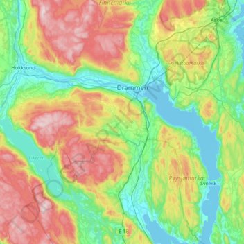
Name: Drammen topographic map, elevation, terrain.

Location: Drammen, Buskerud, Norway (59.53043 9.94322 59.86254 10.42450)

Average elevation: 686 ft

Minimum elevation: -10 ft

Maximum elevation: 2,123 ft

Gear up for your next adventure:

🌄Hiking Binoculars - Compact binoculars for scenic views and trail spotting
🏕️Family Camping Gear - Essentials for group camping trips
🎒Waterproof Dry Bags - Keep your electronics and maps dry inside your pack
🔊Portable Camp Speaker - Music and alerts at camp
🔋Solar Power Banks - Keep your GPS and phone charged in remote wilderness areas

As an Amazon Associate, this site earns from qualifying purchases at no extra cost to you.