Geolocate

McGregor topographic map

Click on the map to display elevation.

About this map

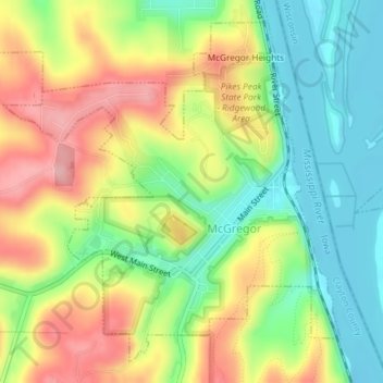
Name: McGregor topographic map, elevation, terrain.

Location: McGregor, Clayton County, Iowa, United States (43.01239 -91.20072 43.03634 -91.16818)

Average elevation: 787 ft

Minimum elevation: 607 ft

Maximum elevation: 1,093 ft

Clayton County trails, hiking, mountain biking, running and outdoor activities

Other topographic maps

Click on a map to view its topography, its elevation and its terrain.

Volga River

United States > Iowa > Clayton County

Average elevation: 879 ft

Volga River

United States > Iowa > Clayton County

Average elevation: 879 ft

Volga River

United States > Iowa > Clayton County

Average elevation: 879 ft

Volga River

United States > Iowa > Clayton County

Average elevation: 879 ft

Gear up for your next adventure:

🔭Stargazing Telescopes - Perfect for camping in low-light pollution areas shown on maps
🧭Outdoor Navigation Book - Learn advanced navigation skills
🛰️Handheld GPS Units - Professional satellite navigators for precise backcountry mapping
🪄Magnetic Compass - Accurate compass for navigation
📷Action Camera - Capture your outdoor adventures in HD

As an Amazon Associate, this site earns from qualifying purchases at no extra cost to you.